The whole planet at storm-resolving resolution: a 24-hour free-running STRATA forecast (top) and the SCREAM physics-model ground truth (bottom) from the same initial condition, at 4.9 km and 10-minute resolution. Water vapour in blue, rain intensity in warm colors. Both play in sync; switch to Swipe to compare them in a single frame.
Abstract
Kilometer-scale convection shapes precipitation extremes, tropical organization, and cloud feedbacks, but most global atmospheric models approximate these processes at 25–100 km resolution. Global storm-resolving physics models resolve convective systems explicitly, but at a cost—roughly one MWh per simulated day on exascale supercomputers—that limits long-duration simulation. We introduce STRATA (Storm-resolving Tile-based autoRegressive Atmosphere Transformer Architecture), the first autoregressive AI emulator for global storm-resolving atmospheric dynamics. STRATA is trained on the highest-resolution atmospheric dataset yet used for global AI emulation: 17 days of SCREAM physics-model output at 4.9-km resolution (~25 million grid cells) sampled every 10 minutes. Our central premise is that on 10-minute timescales atmospheric dynamics are predominantly local, so training on small spatial tiles trades scarce global temporal samples for abundant local spatial samples and enables global rollout via overlapping-tile blending. STRATA combines 3D patch embedding and local 3D neighborhood attention, a novel Stereographic Rotary Position Embedding (StereoRoPE) for grid-invariant encoding, and a pixel-space de-aliasing decoder that suppresses patch-scale rollout artifacts. An iso-FLOP scaling study reveals that km-scale emulation requires ~10× more FLOPs per grid point than coarse-resolution AI weather models, consistent with the higher information density of convective-scale dynamics. Trained on only 17 days of data, STRATA produces stable 24-hour global rollouts with realistic km-scale dynamics across diverse regimes, though large-scale biases develop with lead time. It achieves 48 simulation days per megawatt-hour—about 50 times better energy efficiency than the SCREAM physics model—and 741 simulated days per wall-clock day at 512 H100 GPUs. Code and dataset are publicly available.
Method
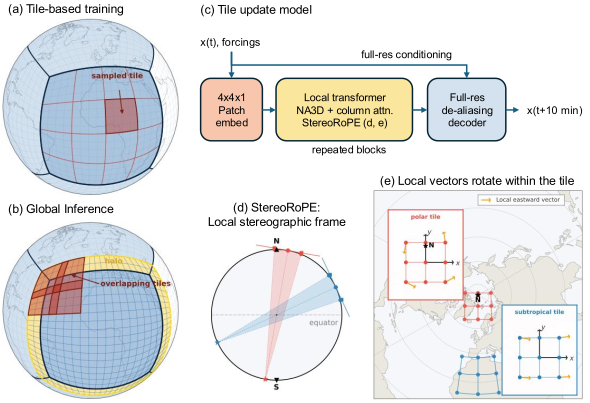
- Train on tiles, roll out globally. On 10-minute timescales the dynamics are predominantly local, so STRATA trains on small spatial tiles and produces global forecasts by blending overlapping tiles.
- 3D patch embedding and local 3D neighborhood attention.
- StereoRoPE, a stereographic rotary position embedding that gives a grid-invariant encoding.
- Pixel-space de-aliasing decoder that suppresses patch-scale artifacts during long rollouts.
For full details on the architecture, training data, scaling study and evaluation, please see our paper.
Regional Zoom-ins
Where the zoom-ins are: STRATA (left) and SCREAM (right) near-surface humidity and precipitation, with the six regions boxed and shown below the maps.
Each clip below is the same 24-hour free rollout at 4.9 km and 10-minute resolution: SCREAM ground truth (top) vs. STRATA (bottom). Columns: vertical velocity, precipitation, near-surface humidity and near-surface zonal wind. The playback-quality toggle at the top applies here too.
Tropical cyclone (S. Indian Ocean)#
Multi-armed spiral structure, eyewall convection, and precipitation banding.
Shallow clouds (SE Pacific)#
Cellular boundary-layer convection is preserved rather than smoothed to a mean state.
Midlatitude cold front (N. Atlantic)#
A sharp frontal line in vertical velocity and a narrow precipitation band along the cold front.
Intertropical Convergence Zone (E. Pacific)#
Organized deep convection along the ITCZ with gravity-wave structures.
Maritime Continent#
Land–sea organized convection with a diurnal cycle and complex orographic effects.
Orographic precipitation (Northern Andes)#
Topographically forced precipitation along the eastern slopes of the Andes.